Tabe of Content
If you’ve ever lived in Philadelphia, you might have noticed that the neighborhood boundaries there are not very clear. Unlike many other cities in the US, where the city government lays out clear lines between neighborhoods, Philly’s boundaries can be fuzzy.
This lack of clear boundaries has been an issue for a long time. You can often hear people arguing over which neighborhood a particular area belongs to. This confusion can be a big problem, especially in industries like real estate, where knowing the exact location of a property is of utmost importance.
Yes, we know! Neighborhoods change over time as demographics shift and boundaries evolve. But it would be helpful for everyone in the community to have a clear idea of where one neighborhood ends and another begins.
In this article, we will explore why neighborhood boundaries matter and why Philadelphia lacks these boundaries. Let’s dive in!
Understanding Neighborhood Boundaries
First, let’s define the term “neighborhood”. According to Wikipedia “A neighborhood is a geographically localized community within a larger city, town, suburb, or rural area, sometimes consisting of a single street and the buildings lining it.”
Different things, like history, can set neighborhood boundaries and determine how an area has grown. But mostly, they are decided by physical features, like:
- Major Streets: Major roads are a common way to say where one neighborhood ends and another begins. They’re easy to spot and remember. For example, Broad Street divides North and South Philly. The problem with this method is that in this case one side of the street would be in one neighborhood and the other side in another neighborhood. Using a smaller street next to the big one as the boundary can solve this problem.
- Natural Features: Things like parks or train lines can be boundaries too, but they’re not as common in Philly.
- Different Land Use: When an area changes from homes to shops, that can mark the edge of a neighborhood. Or if the buildings change a lot, like going from houses to apartments.
Note that neighborhoods can be affected by their surroundings, even if they’re not inside their borders. For example, a university might attract a younger, student-oriented population to a surrounding neighborhood, while a hospital might draw in families seeking medical care. The presence of major institutions or infrastructure often drives physical development and change within a neighborhood.
Why Do Neighborhood Boundaries Matter?
Neighborhoods are more than just streets and houses. They are vibrant communities where we live, work, and entertain. Now, imagine a city without clear neighborhood borders. Confusing, right? You won’t understand this until you live in such a city. This is the case in the City of Brotherly Love; Philadelphia neighborhood boundaries are not defined clearly. But have you ever wondered why defined neighborhood boundaries are important?
Let’s see!
- It provides more clarity for residents. Knowing your neighborhood helps you navigate local resources, services, and events.
- Unclear boundaries can create challenges for businesses in terms of marketing, attracting customers, and understanding the demographics of their target market.
- Without clear boundaries, it’s challenging to determine the exact location of a property, which can lead to disagreements over its value and pricing.
- Clear boundaries foster a sense of belonging and shared identity, strengthening community spirit.
- Neighborhoods often have unique identities and cultures. Unclear boundaries can blur these distinctions, leading to a loss of community identity and cohesion. (Personally, I believe this could also be a good thing; we will discuss this in the next section.)
Remember: Boundaries aren’t rigid lines. They evolve with communities. But having a defined framework helps ensure everyone’s on the same page. This is especially important for the Real Estate Industry.
Why Don’t Philadelphia Neighborhoods Have Clear Boundaries?
Unlike many cities with rigidly defined neighborhoods, Philadelphia thrives on a unique system: fluid boundaries. This means residents often have their own mental map of their community, and there’s no single “official” neighborhood everyone agrees on. So you might wonder why the city did not provide an official map to solve this problem! Well, the reason could be among the following:
- Remember how we told you unclear boundaries can blur the distinction between people? This is a good reason for NOT defining Philadelphia neighborhood boundaries. Philadelphia’s vibrant communities often identify more with local culture than defined lines. Rigid boundaries could highlight divisions based on ethnicity, race, or income, which the city avoids.
- Neighborhoods grew naturally over time, shaped by social and economic factors, not government planning. This led to blurred lines that continuously evolve with demographic shifts and new developments.
- Residents and community groups often create and popularize neighborhood names, sometimes leading to disputes. Residents have strong attachments to their neighborhoods, identifying with different names based on historical significance or personal preferences. This diversity makes establishing uniform boundaries challenging.
- Philadelphia constantly changes, with gentrification, new projects, and residents shaping its landscape. Rigid boundaries wouldn’t capture this ever-evolving essence.
What Has Shaped Philadelphia Neighborhoods?
So we have the problem of clear boundaries between Philadelphia neighborhoods. But what has shaped the neighborhoods as they are now? Instead of official maps, here’s what shapes Philadelphia neighborhoods:
- Resident perception: Each person has their own mental map of their neighborhood, influenced by personal experiences and community connections.
- Registered Community Organizations (RCOs): These resident groups can choose names for their areas, creating “mini-neighborhoods” within larger communities.
- Historical context: Many neighborhood names have historical roots, reflecting the area’s past and adding to its unique identity.
- Gentrification and Urban Development: As areas change, residents, developers, and businesses propose new names to reflect transformations.
This system presents challenges, like confusion for newcomers and planning complexities. So that’s why we think we need a good map that clearly shows Philadelphia neighborhood boundaries!
How Can We Define Philadelphia Neighborhood Boundaries?
Without an official neighborhood map, people often rely on police and council districts or zip codes, but these aren’t true boundaries. Some individuals and businesses have attempted to create neighborhood maps, with the Philadelphia Inquirer magazine offering one good example.
So, the question arises: how can we define the boundaries of Philadelphia neighborhoods? Researchers are turning to Geographic Information System (GIS) tools to create more accurate and resident-informed boundaries. But what factors must be considered to create this map?
1. Determine Your Purpose
First and foremost, it is important to understand the purpose for which this map is being prepared. Many factors can distinguish neighborhoods from one another. For example, if you are separating neighborhoods based on housing market value, your boundaries might differ compared to someone who is drawing boundaries based on income levels or racial demographics. Although there is typically a relationship between these factors, it is not always the case. For instance, people with high-income levels typically live in areas with high real estate market value, but can we definitively establish a relationship between real estate market value and racial demographics? I don’t think so!
2. Research Locally
A valuable resource for creating neighborhood maps in Philadelphia is the people themselves. Engaging with residents, community leaders, or real estate agents familiar with specific areas can provide insight into how people perceive and define neighborhood boundaries. However, studies indicate that people have varying views on neighborhood size and boundaries. To address this, research helps in defining neighborhood boundaries by considering residents’ perceptions with GIS tools.
3. Take Advantage of Current Maps and Zip Codes
There are many online maps created by residents, community organizations, and real estate companies showing neighborhood boundaries, which can serve as a starting point. However, these maps may not capture all smaller neighborhoods or reflect recent changes, and they may differ based on individual perspectives.
Also, while not perfect, ZIP codes can sometimes offer a rough idea of neighborhood boundaries. However, it’s essential to note that ZIP codes often overlap neighborhoods and may not neatly align with perceived boundaries.
4. Look for Physical Features
When defining neighborhood boundaries, physical features such as rivers, parks, major streets, or commercial districts can serve as natural or man-made dividing lines. These features often influence how people perceive and navigate their surroundings, and as explained earlier, physical features are useful indicators for defining neighborhood borders.
5. Look for a Focal Point
Some neighborhoods have a central focal point, such as a prominent landmark, cultural institution, or commercial hub, around which the community revolves. They often represent the heart of the community.
6. Get Help from a GIS Expert
Collaborate with professionals skilled in using Geographic Information Systems (GIS) software. GIS specialists possess the technical skills and knowledge to analyze spatial data, incorporate various factors influencing neighborhood boundaries, and produce detailed, data-driven maps.
Remember, there isn’t always a single “correct” definition of a neighborhood boundary. It’s important to consider different perspectives and factors when trying to understand how Philadelphia neighborhood boundaries are defined.
Conclusion
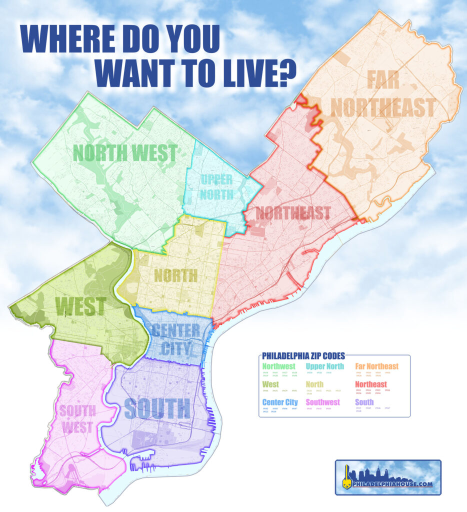
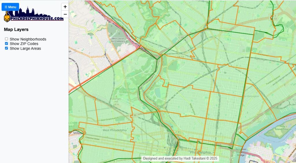
At Philadelphiahouse, we know that getting to know the city’s neighborhoods is crucial, whether you’re buying a home, selling property, or just getting familiar with your surroundings.
That’s why we’ve created an interactive map on our website, designed to make it simple to explore the city’s major sections and neighborhoods. By using our map, you’ll get a clearer view of Philadelphia’s unique geography. It’s designed to help you see how neighborhoods evolve and where they connect, giving you the flexibility to explore the city like never before. Whether you’re a real estate agent trying to pinpoint specific areas for your clients or a resident learning about your city’s diversity, this map is your go-to tool for better understanding Philadelphia.
References:
- https://en.wikipedia.org/wiki/List_of_Philadelphia_neighborhoods
- https://www.inquirer.com/philly/news/pennsylvania/philadelphia/neighborhoods-philadelphia-map-names-list-20180917.html
- https://www.huduser.gov/portal/periodicals/cityscpe/vol14num2/Cityscape_July2012_defining_neighborhoods_res.pdf
- https://www.inquirer.com/philly/business/real_estate/residential/philadelphia-neighborhood-name-changes-20170721.html#loaded
- https://localpreservation.github.io/neighborhoods/guides/neighborhood-boundaries/#:~:text=Natural%20features%20such%20as%20parks,also%20used%20to%20define%20boundaries.
- https://www.inquirer.com/philly/news/pennsylvania/philadelphia/neighborhoods-philadelphia-map-names-list-20180917.html#loaded
- https://www.planning.org/pas/reports/report141.htm#:~:text=Physical%20Boundaries&text=.%20.%20.the%20key%20elements%20in,%3B%20major%20highways.%20.%20.%20.
- https://whyy.org/articles/philadelphia-the-city-of-neighborhoods/
- https://www.pewtrusts.org/~/media/assets/2016/05/philadelphias_changing_neighborhoods.pdf
- https://portal.cops.usdoj.gov/resourcecenter/ric/Publications/cops-w0550-pub.pdf
- https://centercityteam.com/philadelphia-neighborhood/
- https://muse.jhu.edu/article/652535/
- https://hiddencityphila.org/2021/12/repercussions-of-racist-maps-still-impact-neighborhoods-today/
- https://www.reddit.com/r/appraisal/comments/12rwzqc/how_are_you_all_determining_neighborhood/
- https://savingplaces.org/stories/10-on-tuesday-10-factors-in-establishing-local-historic-district-boundary-lines#:~:text=3.,limits%20of%20the%20settled%20area.


Últimamente he visto mucha publicidad de Jugabet, ¿alguien ha probado
el retiro? https://www.pirateriadigital.es/2025/09/01/gamdom-casino-maximisez-vos-gains-grace-a-la-science-des-probabilites-2/
GalacticCasino! The name is cool, and the games are pretty fun. Feels like there’s a decent chance to win something, and who doesn’t love that? See what I’m talking about: galacticcasino
Gave 718betwin a try. Simple and straightforward with a good range of games. Sign up was easy and I was playing in minutes. Check it out if you want quick fun: 718betwin
7777betio is alright! I enjoyed playing several different games, and the site is pretty user-friendly. Might be a good place to use some bonus offers. Try your luck: 7777betio